MAP
MAP
The Canadian Pipeline
The Canadian Pipeline
Use this map to explore the significance of, and controversy surrounding, the Enbridge Northern Gateway Pipeline and oil tanker project. Students learn about the issues regarding the impact of the oil tankers on the environment and on Indigenous communities, the failure of Enbridge to consult with the First Nations, and the ultimate rejection of the pipeline.
Grades
5 - 8
Subjects
Conservation, Earth Science, Geology, Engineering, Geography, Social Studies
Image
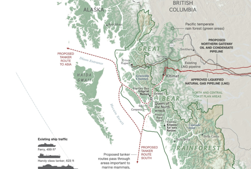
Oil Tanker Routes
The proposed Enbridge Northern Gateway Pipeline would send oil tankers along ecologically sensitive routes in Canada's Great Bear Rainforest.
Infographic by National Geographic
Educator Idea
The Trans Mountain Pipeline in Canada is used to transport oil from Alberta to the west coast of British Columbia where it is exported to foreign markets. Because of the significance of oil exports to the Canadian economy, multiple projects have been proposed to expand the pipeline system. Explain the controversy to students. The Enbridge Northern Gateway Pipeline, because of the oil tanker routes, was widely opposed by environmental groups and First Nations (the Indigenous peoples of Canada who are not Inuit or Metis), as it posed health risks to indigenous communities and threatened local ecosystems. The Canadian Federal Court killed the project after deciding that Enbridge did not adequately consult with the First Nations that would be affected by the project and did not fully research the environmental risks. Using the map, show students how the proposed pipeline would cross Alberta to Kitimat, British Columbia, and then large oil tankers leaving Kitimat would cross the Great Bear Rainforest and the Douglas Channel.
Using the sources below, have students research how pipelines work, how they are monitored, and the incidence of spills. Have them list the pros and cons of expanding the pipeline. As an extension activity, have them research the communities and resources in the Great Bear Rainforest and the Douglas Channel and analyze the economic impact of building the pipeline, the risk of a spill, and the subsequent economic losses that might occur to the economy if there were a spill.
Credits
Media Credits
The audio, illustrations, photos, and videos are credited beneath the media asset, except for promotional images, which generally link to another page that contains the media credit. The Rights Holder for media is the person or group credited.
Director
Author
Production Managers
Program Specialists
Producer
other
Last Updated
August 11, 2026
User Permissions
For information on user permissions, please read our Terms of Service. If you have questions about how to cite anything on our website in your project or classroom presentation, please contact your teacher. They will best know the preferred format. When you reach out to them, you will need the page title, URL, and the date you accessed the resource.
Media
If a media asset is downloadable, a download button appears in the corner of the media viewer. If no button appears, you cannot download or save the media.
Text
Text on this page is printable and can be used according to our Terms of Service.
Interactives
Any interactives on this page can only be played while you are visiting our website. You cannot download interactives.