A vast, interconnected network of ancient cities was home to millions more people than previously thought.
Grades
3 - 12
Subjects
Anthropology, Archaeology, Geography, Physical Geography, Social Studies, Ancient Civilizations
Image
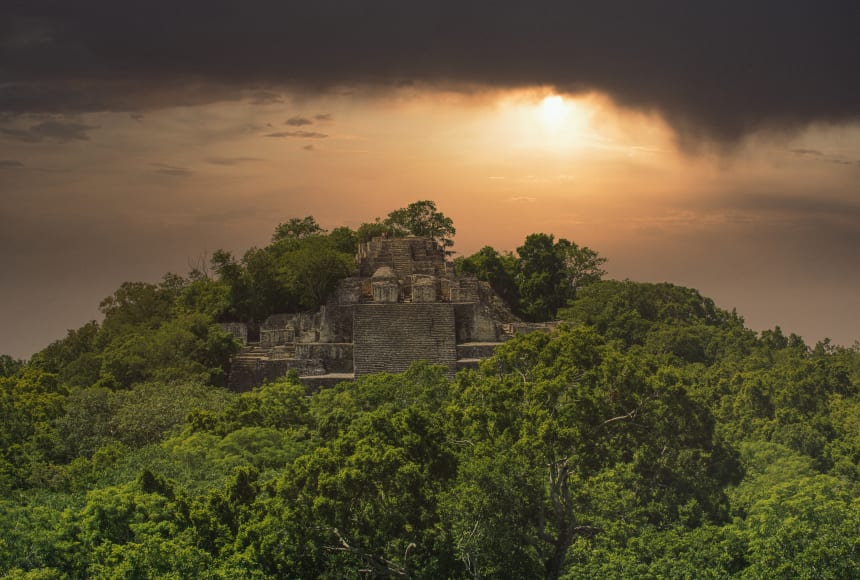
Mayan Calakmul Pyramid
Pyramids, like Calakmul, in Campeche, Mexico, are iconic of the Maya. But infrastructure, its roads and irrigation, were the backbone of Maya civilization.
Andy Cannon/Shutterstock
Leveled by
Share on Twitter
Share on Facebook
Share on Pinterest
Share on Google Classroom
Share on MS Teams
Share via email
Print
Selected text level
Using a revolutionary technology known as (short for “Light Detection And Ranging”), scholars digitally removed the tree canopy from aerial images of the now-unpopulated landscape, revealing the of a sprawling pre-Columbian that was far more complex and interconnected than most specialists had supposed.
“The LiDAR images make it clear that this entire region was a settlement system whose scale and population density had been grossly underestimated,” said Thomas Garrison, an Ithaca College archaeologist and National Geographic Explorer who specializes in using digital technology for archaeological research.
Garrison is part of a consortium of researchers who are participating in the project, which was spearheaded by the PACUNAM Foundation, a Guatemalan nonprofit that fosters scientific research, sustainable development, and cultural heritage preservation.
The project mapped more than 2,100 square kilometers (800 square miles) of the Maya Biosphere Reserve in the Petén region of Guatemala, producing the largest LiDAR data set ever obtained for archaeological research.
The results suggest that Central America supported an advanced, ancient civilization that was, at its peak some 1,200 years ago, more comparable to sophisticated cultures such as ancient Greece or China than to the scattered and sparsely populated city states that ground-based research had long suggested.
In addition to hundreds of previously unknown structures, the LiDAR images show raised highways connecting urban centers and quarries. Complex and terracing systems supported intensive agriculture capable of feeding masses of workers who dramatically reshaped the landscape.
The ancient Maya never used the wheel or beasts of burden, yet “this was a civilization that was literally moving mountains,” said Marcello Canuto, a Tulane University archaeologist and National Geographic Explorer who participated in the project.
“We’ve had this western conceit that complex civilizations can’t flourish in the tropics, that the tropics are where civilizations go to die,” said Canuto, who conducts archaeological research at a Guatemalan site known as La Corona. “But with the new LiDAR-based evidence from Central America and [Cambodia’s] Angkor Wat, we now have to consider that complex societies may have formed in the tropics and made their way outward from there.”
Surprising Insights “LiDAR is revolutionizing archaeology the way the Hubble Space Telescope revolutionized astronomy,” said Francisco Estrada-Belli, a Tulane University archaeologist and National Geographic Explorer. “We’ll need 100 years to go through all [the data] and really understand what we’re seeing.”
Already, though, the survey has yielded surprising insights into , interurban connectivity, and militarization in the Maya Lowlands. At its peak in the Maya classic period (approximately C.E. 250–900), the civilization covered an area about twice the size of medieval England, but it was far more densely populated.
“Most people had been comfortable with population estimates of around five million,” said Estrada-Belli, who directs a multidisciplinary archaeological project at Holmul, Guatemala. “With this new data it’s no longer unreasonable to think that there were 10 million to 15 million people there—including many living in low-lying, swampy areas that many of us had thought uninhabitable.”
Virtually all the Mayan cities were connected by causeways wide enough to suggest that they were heavily trafficked and used for trade and other forms of regional interaction. These highways were elevated to allow easy passage even during rainy seasons. In a part of the world where there is usually too much or too little precipitation, the flow of water was meticulously planned and controlled via canals, , and .
Among the most surprising findings was the ubiquity of defensive walls, ramparts, terraces, and fortresses. “Warfare wasn’t only happening toward the end of the civilization,” Garrison said. “It was large-scale and systematic, and it endured over many years.”
The survey also revealed thousands of pits dug by modern-day . “Many of these new sites are only new to us; they are not new to looters,” said Marianne Hernandez, president of the PACUNAM Foundation.
Environmental is another concern. Guatemala is losing more than 10 percent of its forests annually, and habitat loss has accelerated along its border with Mexico as trespassers burn and clear land for agriculture and human settlement.
“By identifying these sites and helping to understand who these ancient people were, we hope to raise awareness of the value of protecting these places,” Hernandez said.
The survey is the first phase of the PACUNAM LiDAR Initiative, a three-year project that will eventually map more than 14,000 square kilometers (5,000 square miles) of Guatemala’s lowlands, part of a pre-Columbian settlement system that extended north to the Gulf of Mexico.
“The ambition and the impact of this project is just incredible,” said Kathryn Reese-Taylor, a University of Calgary archaeologist and Maya specialist who was not associated with the PACUNAM survey. “After decades of combing through the forests, no archaeologists had stumbled across these sites. More importantly, we never had the big picture that this data set gives us. It really pulls back the veil and helps us see the civilization as the ancient Maya saw it.”
Credits
Media Credits
The audio, illustrations, photos, and videos are credited beneath the media asset, except for promotional images, which generally link to another page that contains the media credit. The Rights Holder for media is the person or group credited.
other
Last Updated
April 19, 2024
User Permissions
For information on user permissions, please read our Terms of Service. If you have questions about how to cite anything on our website in your project or classroom presentation, please contact your teacher. They will best know the preferred format. When you reach out to them, you will need the page title, URL, and the date you accessed the resource.
Media
If a media asset is downloadable, a download button appears in the corner of the media viewer. If no button appears, you cannot download or save the media.
Text
Text on this page is printable and can be used according to our Terms of Service.
Interactives
Any interactives on this page can only be played while you are visiting our website. You cannot download interactives.