ARTICLE

leveled

ARTICLE

leveled

Exclusive: Laser Scans Reveal Maya “Megalopolis” Below Guatemalan Jungle

Exclusive: Laser Scans Reveal Maya “Megalopolis” Below Guatemalan Jungle

A vast, interconnected network of ancient cities was home to millions more people than previously thought.

Grades

3 - 12

Subjects

Anthropology, Archaeology, Geography, Physical Geography, Social Studies, Ancient Civilizations

Image

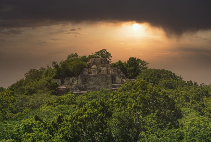
Mayan Calakmul Pyramid

Pyramids, like Calakmul, in Campeche, Mexico, are iconic of the Maya. But infrastructure, its roads and irrigation, were the backbone of Maya civilization.

Andy Cannon/Shutterstock
Pyramids, like Calakmul, in Campeche, Mexico, are iconic of the Maya. But infrastructure, its roads and irrigation, were the backbone of Maya civilization.
Leveled by
Newsela
Selected text level

Scientists have made a new discovery about the Maya. They found hidden ruins in Guatemala. This is a country in Central America. These ruins include many human-made buildings.

Scholars found these ruins with a new technology called LiDAR. It stands for Light Detection And Ranging. A LiDAR system can be put on a plane. Then the system uses its lasers to measure distances to Earth. Then the system makes a 3-D image of the ground. The images show the ruins of the Maya civilization. The ruins were far larger than people had thought.

Protecting History of Region
A group of scientists are studying the Maya. They want to explore nature using science. They also want to protect the history of the region.

The pictures mapped more than 2,100 kilometers (800 miles) of land. That is just a little bit bigger than the Hawaiian island Maui, in the United States. Scientists now have more pictures to study than ever before.

The pictures show that Maya communities were advanced. People thought the Maya community was simple. Now, they compare the Maya to ancient Greece or China.

Maya Cities Began in Forests
The images show highways that connected cities. The Maya had also created systems to collect water to grow crops on large farms. Lots of workers helped change the lands around them.

The Maya never had wheels or used animals to move things. Still, they were "moving mountains," scientist Marcello Canuto said.

Scientists did not think people could live in the forests. These new pictures prove them wrong. They show Maya cities began in forests.

LiDAR is changing how researchers understand the past. They will be studying these pictures for many years.

Maya communities were large and strong 1,100 to 1,800 years ago. They covered an area twice the size of England, but there were more people living closer together.

In the past, scholars thought there were only five million Maya. Now they think there were 10 million to 15 million people.

Maya cities were connected by wide roads. People traded along these highways. Water was controlled with canals and water reserves. Roads were raised up so they would not get flooded.

War was Common
Researchers found many walls and terraces. These buildings show that war was common for the Maya. This was true especially as they grew.

Some pits that were found were dug by modern-day people. They wanted to steal from the ruins. Thieves had found these places before scientists.

Harming the environment is another problem in the area. Guatemala loses one-tenth of its forests each year. Unwelcome visitors burn and clear the land.

Finding ruins may protect these places.

Scholars will take pictures for three years. Almost 14,000 kilometers (5,000 miles) of Guatemala's lowlands will be mapped. That is two times the size of the U.S. state of Delaware. Large Maya cities were found in these lowlands.

These photographs will help scholars understand the Maya community.

Media Credits

The audio, illustrations, photos, and videos are credited beneath the media asset, except for promotional images, which generally link to another page that contains the media credit. The Rights Holder for media is the person or group credited.

other
Last Updated

April 19, 2024

For information on user permissions, please read our Terms of Service. If you have questions about how to cite anything on our website in your project or classroom presentation, please contact your teacher. They will best know the preferred format. When you reach out to them, you will need the page title, URL, and the date you accessed the resource.

Media

If a media asset is downloadable, a download button appears in the corner of the media viewer. If no button appears, you cannot download or save the media.

Text

Text on this page is printable and can be used according to our Terms of Service.

Interactives

Any interactives on this page can only be played while you are visiting our website. You cannot download interactives.