ENCYCLOPEDIC ENTRY

ENCYCLOPEDIC ENTRY

Köppen Climate Classification System

Köppen Climate Classification System

The Köppen climate classification system is one of the most common climate classification systems in the world. It is used to denote different climate regions on Earth based on local vegetation.

Grades

5 - 8

Subjects

Earth Science, Climatology, Geography, Social Studies, World History

Image

Koppen Classification Map

The Köppen-Geiger system uses colors and shades to classify the world into five climate zones based on criteria like temperature, which allows for different vegetation growth.

Map by H.E. Beck, N.E. Zimmermann, T.R. McVicar, N. Vergopolan, A. Berg, and E.F. Wood
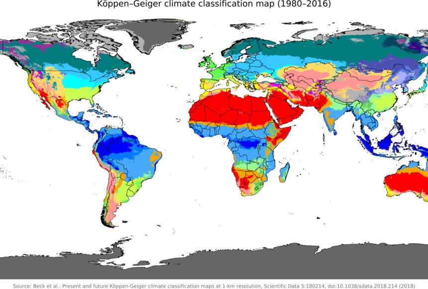
The Köppen-Geiger system uses colors and shades to classify the world into five climate zones based on criteria like temperature, which allows for different vegetation growth.

The Köppen climate classification system categorizes climate zones throughout the world based on local vegetation. Wladimir Köppen, a German botanist and climatologist, first developed this system at the end of the 19th century, basing it on the earlier biome research conducted by scientists. These scientists learned that vegetation and climate are intricately linked. The vegetation that grows in a region is dependent on the temperature and precipitation there, which are two key factors of climate. Areas with more rainfall and higher temperatures contain more forests while regions with less rainfall tend to be deserts. The Köppen climate classification system has been enhanced and modified several times since it was first published.

The system divides the world into five climate zones based on criteria, usually temperature, which allows for different vegetation growth. Köppen’s map used different colors and shades to represent the different climate zones of the world. While most of the zones are organized based on the temperature of a region, Zone B focuses on the aridity of a region. The zones are as follows:

Zone A: tropical or equatorial zone (represented by blue colors on most maps)

Zone B: arid or dry zone (represented by red, pink, and orange colors on most maps)

Zone C: warm/mild temperate zone (represented by green colors on most maps)

Zone D: continental zone (represented by purple, violet, and light blue colors on most maps)

Zone E: polar zone (represented by gray colors on most maps)

Each zone is further subdivided based on temperature or dryness. For example, Zone A has three subdivisions: Zone Af has no dry season, Zone Am has a short dry season, and Zone Aw has a winter dry season. Zone B is divided into categories related to regions such as hot, arid deserts (Zone BWh); cold, arid deserts (Zone BWk); hot, arid steppes (Zone BSh); and cold, arid steppes (Zone BSk). Climate zones C and D are broken into categories based on when the dry seasons occur in the zones, as well as the coldness of the summer or the warmth of the winter. Zone E climates are separated into tundra regions (Zone ET) or snow and ice regions (Zone EF). Additionally, some modern revisions to the system include a sixth region, known as Zone H. This represents a highland climate located at mountainous elevations.

Köppen’s classification maps are still used by scientists and climatologists to this day. Although he published his first map in the early 1900s, Köppen continued to update it until his death in 1940. Subsequent climatologists, including Rudolf Geiger, updated versions of this map, which often include Geiger’s name as well. At the time of writing, a recent revision to this map was published in 2018.

Media Credits

The audio, illustrations, photos, and videos are credited beneath the media asset, except for promotional images, which generally link to another page that contains the media credit. The Rights Holder for media is the person or group credited.

Director
Tyson Brown, National Geographic Society
Author
National Geographic Society
Production Managers
Gina Borgia, National Geographic Society
Jeanna Sullivan, National Geographic Society
Program Specialists
Sarah Appleton, National Geographic Society, National Geographic Society
Margot Willis, National Geographic Society
Producer
Clint Parks
Intern
Roza Kavak
other
Last Updated

July 19, 2024

For information on user permissions, please read our Terms of Service. If you have questions about how to cite anything on our website in your project or classroom presentation, please contact your teacher. They will best know the preferred format. When you reach out to them, you will need the page title, URL, and the date you accessed the resource.

Media

If a media asset is downloadable, a download button appears in the corner of the media viewer. If no button appears, you cannot download or save the media.

Text

Text on this page is printable and can be used according to our Terms of Service.

Interactives

Any interactives on this page can only be played while you are visiting our website. You cannot download interactives.

Related Resources