ENCYCLOPEDIC ENTRY

ENCYCLOPEDIC ENTRY

Lewis and Clark Trail

Lewis and Clark Trail

In 1804, Meriwether Lewis and William Clark set out on a two-year journey to document the newly purchased Louisiana Territory. On the way to the Pacific, they collected information on plants, animals, and about some of the Native American nations living in the area.

Grades

9 - 12

Image

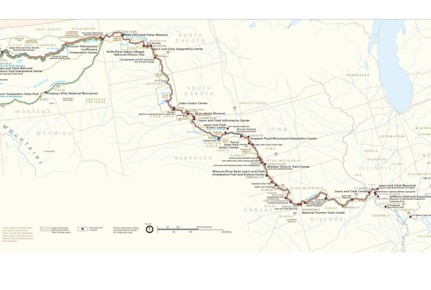
Lewis and Clark Trail Map

Meriwether Lewis and William Clark led an expedition to survey the newly purchased territory acquired from the French, known as the Louisiana Purchase. The trek sent the party of about 40 from St. Louis to the Pacific Ocean.

Image by the United States National Park Service
Meriwether Lewis and William Clark led an expedition to survey the newly purchased territory acquired from the French, known as the Louisiana Purchase. The trek sent the party of about 40 from St. Louis to the Pacific Ocean.

Today, the Lewis and Clark Trail is a 5,955-kilometer (3,700-mile) long historical trail in the United States National Park Service system. It passes through 11 states and follows the path Meriwether Lewis and William Clark took as they explored the lands acquired through the Louisiana Purchase.

In 1803, President Thomas Jefferson requested and received congressional approval for a team of men and $2,500 [about $78,200 in 2015 U.S. money, according to a website by Rodney Edvinsson, associate professor of Economic History at Stockholm University] to explore “even to the Western Ocean” and to “have conferences with the natives.” He asked his former personal secretary, Meriwether Lewis, to lead the expedition. Lewis convinced William Clark, one of his former military commanders, to join him.

In a letter to Lewis, Jefferson explained the journey’s primary mission was to explore the area from the Missouri River to the Pacific Ocean. Jefferson hoped to find a water route to the Pacific Ocean—the long-sought-after Northwest Passage.

This was not Jefferson’s only goal. He also wanted to gather knowledge about the native people living along the route and to establish positive relationships between his government and theirs. Additionally, he asked Lewis and Clark to document the climate, animals, plants, and minerals they encountered along the way.

In May of 1804, Lewis and Clark and a team of about 40 set out from St. Louis, then the capital of the Orleans Terriotory. This so-called Corps of Discovery traveled for about 18 months before reaching the Pacific Ocean in November of 1805. Much of their journey followed the Missouri and Columbia Rivers. The return journey took just under a year, ending in September of 1806.

Along the way, Lewis and Clark received valuable guidance from the only woman in the group, a Shoshone named Sacagawea. Sacagawea was married to a French fur trader who had joined the Corps of Discovery, and she had just given birth to an infant son. Sacagawea shared her knowledge of the land. Historians also speculate her presence helped ease the fear of the Native American people the company encountered on the excursion.

Lewis and Clark (along with others in the Corps) kept detailed journals throughout their expedition. They documented 120 animals and 182 plants, many of which were previously unknown to the Americans, and they returned with specimens of some. Clark drew detailed maps of the territory. They also brought back knowledge of nine Native American languages.

The United States deemed the Lewis and Clark expedition so successful that Congress paid the Corps of Discovery double the expected pay and gave each member hundreds of acres of land. Two-hundred years later, the Lewis and Clark expedition is still recognized as one of the greatest explorations in U.S. history.

Media Credits

The audio, illustrations, photos, and videos are credited beneath the media asset, except for promotional images, which generally link to another page that contains the media credit. The Rights Holder for media is the person or group credited.

Director
Tyson Brown, National Geographic Society
Author
National Geographic Society
Production Managers
Gina Borgia, National Geographic Society
Jeanna Sullivan, National Geographic Society
Program Specialists
Sarah Appleton, National Geographic Society, National Geographic Society
Margot Willis, National Geographic Society
Producer
Clint Parks
Intern
Roza Kavak
other
Last Updated

October 19, 2023

For information on user permissions, please read our Terms of Service. If you have questions about how to cite anything on our website in your project or classroom presentation, please contact your teacher. They will best know the preferred format. When you reach out to them, you will need the page title, URL, and the date you accessed the resource.

Media

If a media asset is downloadable, a download button appears in the corner of the media viewer. If no button appears, you cannot download or save the media.

Text

Text on this page is printable and can be used according to our Terms of Service.

Interactives

Any interactives on this page can only be played while you are visiting our website. You cannot download interactives.

Related Resources