The Nile River flows over 6,800 kilometers (4,000 miles) before emptying into the Mediterranean Sea. For thousands of years, the river has provided a source of irrigation to transform the dry area around it into lush agricultural land. Today, the river continues to be a vital freshwater resource for millions of northeast Africans who rely on it for irrigation, drinking water, fishing, and hydroelectric power.
Grades
5 - 8
Subjects
Anthropology, Sociology, Geography, Social Studies, Ancient Civilizations
Image
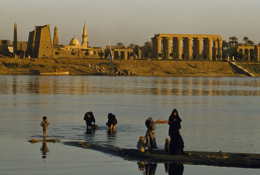
Women and Children on the Banks of the Nile
Even today, families come to the banks of the Nile River to gather water for their day, against the backdrop of ancient Egyptian ruins.
The , the longest in the world, flows from south to north through northeastern Africa. It begins in the rivers that flow into Lake Victoria (located in modern-day Kenya, Tanzania and Uganda) and travels more than 6,800 kilometers (4,000 miles) to the north, emptying into the Mediterranean Sea on Egypt’s coast. The river’s three main are the Atbara, the and the . The entire Nile River basin—made up of interconnected streams, lakes and rivers—threads its way through 11 African countries: Burundi, Democratic Republic of the Congo, Egypt, Eritrea, Ethiopia, Kenya, Rwanda, South Sudan, Sudan, Tanzania and Uganda.
The Nile River was critical to the development of . The soil of the Nile River between Cairo, Egypt and the Mediterranean Sea is rich in nutrients, due to the large deposits the Nile leaves behind as it flows into the sea. The banks of the Nile all along its vast length contain rich soil as well, thanks to annual that deposits silt. From space, the contrast between the Nile's lush green river banks and the desert through which it flows is obvious.
For , much of Egypt's food has been in the Nile Delta region. Ancient Egyptians developed methods to increase the amount of land they could use for crops to support a thriving population. Beans, cotton, flax and wheat were important, abundant crops that could be easily stored and traded.
The Nile River Delta was also an ideal growing location for the plant. Ancient Egyptians used the papyrus plant in many ways, such as making cloth, boxes and rope, but by far its most important use was in making paper. Besides using the river's natural resources for themselves and trading them with others, early Egyptians also used the river for bathing, drinking, recreation and transportation. Today, National Geographic Explorer Raghda (Didi) El-Behaedi studies how ancient societies responded to a shrinking water supply, particularly focusing on Lake Moeris and the Nile. Informed by technologies such as remote sensing and GIS, El-Behaedi seeks to better understand ancient landscapes and subsequently bolster cultural heritage preservation efforts in Egypt.
Today, 95 percent of Egyptians live within a few miles of the Nile. Canals bring water from the Nile to irrigate farms and support cities. The river's water is a vital resource for millions of people who depend on it for irrigation, drinking water, fishing and hydroelectric power. The river has served as an important transportation route for thousands of years. Today, some residents of Cairo have begun using private speed boats, water taxis or ferries to avoid crowded streets.
Dams, such as the Aswan Dam in Egypt, have been built to help to tame the river and provide a source of hydroelectric power. However, the silt and that used to flow north, enriching the soil and building the delta, is now building up behind the dam. Instead of growing in size through the soil deposits, the delta is shrinking due to along the Mediterranean Sea. In addition, annual flooding no longer occurs along parts of the Nile. These floods were necessary to flush and clean the water of human and waste. As a result, the water is becoming more polluted.
The many habitats in the Nile River basin support biodiversity in the region. The basin is home to a variety of animals, including the hippopotamus, the monitor lizard and the fearsome Nile crocodile. The Nile River Delta is also a vital winter stopover for millions of birds migrating along the East African flyway.
The rivers and lakes are filled with a variety of freshwater fish, including the sharp-toothed tigerfish and the Nile perch, a large fish that can grow to weigh more than 79 kilograms (175 pounds). Fishing is a way of life for many inhabitants of northeast Africa, who depend on it for food and a way to earn money. Today, however, the Nile River system is threatened by pollution, as it harms the fish and other wildlife that live in its aquatic environment. This pollution is also impacting the people who depend on the Nile for their drinking water and for irrigating their crops.
With so many countries sharing and relying on the interconnected water resource that is the Nile River basin, it is essential for them to cooperate in regard to its use. Unfortunately, these countries do not always agree on how to manage the water supply. One of the countries most impacted by pollution and water shortages is Egypt, which gets 90 percent of its water from the Nile. As the country’s population increases, experts say Egypt’s demand for water may soon exceed its supply. The United Nations predicts that Egypt will face a water shortage by 2025.
This need for cooperation led to the formation of the Nile Basin Initiative (NBI) in 1999. The NBI brings representatives from all 11 countries in the Nile River basin together to discuss ways to manage and share the water. In 2010, one NBI initiative saw four nations—Ethiopia, Rwanda, Tanzania and Uganda—enter into a Nile River water-sharing agreement. The agreement, called the Cooperative Framework Agreement, allows the countries to use the Nile River system in their borders to encourage cooperation and sustainability. Kenya and Burundi later signed onto the agreement, which remains in place today.
There are still disagreements over the management of the Nile's waters. Ethiopia recently built its own dam, the Grand Ethiopian Renaissance Dam, over the Blue Nile tributary. The Blue Nile supplies most of the water that flows into the Nile River. This has created conflict between Ethiopia and the two countries, Egypt and Sudan, that are downriver. Egypt and Sudan depend on the flow of water from the Blue Nile.
The dam, however, is a big benefit to Ethiopia. It will allow all of its citizens to have access to electricity. In 2015, the three "downriver" countries impacted by Ethiopia's dam—Egypt, Ethiopia and Sudan—signed an agreement to cooperate as the dam was built and its reservoir slowly filled. The Grand Ethiopian Renaissance Dam is now Africa's largest dam. It began producing electricity in 2022.
The audio, illustrations, photos, and videos are credited beneath the media asset, except for promotional images, which generally link to another page that contains the media credit. The Rights Holder for media is the person or group credited.
For information on user permissions, please read our Terms of Service. If you have questions about how to cite anything on our website in your project or classroom presentation, please contact your teacher. They will best know the preferred format. When you reach out to them, you will need the page title, URL, and the date you accessed the resource.
Media
If a media asset is downloadable, a download button appears in the corner of the media viewer. If no button appears, you cannot download or save the media.
Text
Text on this page is printable and can be used according to our Terms of Service.
Interactives
Any interactives on this page can only be played while you are visiting our website. You cannot download interactives.