IDEA SET
IDEA SET
Ocean Exploration
Ocean Exploration
Students brainstorm what it means to be an explorer, watch a short video, and write or draw on a world map what they would like to explore in the ocean.
Grades
3 - 8
Subjects
Oceanography, Earth Science, Physical Geography
Loading ...

This resource is also available in Spanish.
The ocean's basins have been explored for many years. Historically, people explored the oceans to find new ways to travel the globe or to establish new trade routes. Today, ocean exploration focuses on the ocean itself, as much of its depths are unexplored.
Extending the Learning
Have students do further research on an ocean location they would like to explore. Have them create a presentation about the location and what they think they might find there.
Tips and Modifications
Laminate the individual sheets of paper and use dry or wet-erase markers so that you can reuse the map.
You can provide magazines, glue, and any other art supplies to the students for use during their brainstorm on the map panel.
Directions
1. Discuss the concept of exploration.
Ask students, What does it mean to be an explorer? In their notebooks, have them finish the sentence, Being an explorer means ... Give students time to complete their thoughts and then have them share their sentences within a small group or with a partner depending on the number of students. Ask groups to share any similarities or differences between their individual definitions with the class.
2. Consider what we know and don't know about the ocean.
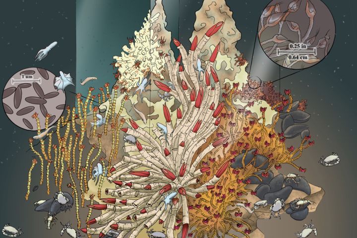
Explain to students that they will view a video of the famous ocean explorer, Robert Ballard. An Explorer-at-Large, Robert Ballard is famous for his discovery of the location of the sunken ship the Titanic and for the discovery of hydrothermal vents. Show students the illustration of a hydrothermal vent from the Resource Carousel, and explain that prior to Ballard's discovery of the vents, people did not know they existed. The vents were a true discovery. Ask students to listen for this story while they watch the video. Show students the short video "Exploring the Edge of Existence" from the Resource Carousel.
Discuss student reactions to the video. Ask: Are you surprised that people know so little about the ocean? In fact, more than 95 percent of the ocean remains unexplored. Give students an opportunity to adjust their sentences from step 1, and discuss any new insights the video gave them about exploration.
3. Brainstorm about ocean exploration on a world map.
Divide students into eight groups, and give each group a panel from the tabletop version of the World Physical MapMaker Kit. Ask students to draw, color, or write on their panel what they think is waiting to be discovered in their part of the ocean.
4. Students share their ideas with each other.
Assemble the eight sections of the map as a class. Give students time to see what each group showed on their sections. Ask: What similarities and differences are there between the tiles? Ask for volunteers to share what they drew and why.
Objectives
Learning Objectives
Students will:
- describe a discovery that has been made by an ocean explorer
- identify an area of the ocean they wish to explore
Teaching Approach
- Learning-for-use
Teaching Methods
- Brainstorming
- Discussions
Skills Summary
This activity targets the following skills:
- Critical Thinking Skills
- Analyzing
- Applying
- Geographic Skills
Connections to National Standards, Principles, and Practices
National Geography Standards
- Standard 3: How to analyze the spatial organization of people, places, and environments on Earth's surface
- Standard 6: How culture and experience influence people's perceptions of places and regions
Ocean Literacy Essential Principles and Fundamental Concepts
- Principle 5e: The ocean is three-dimensional, offering vast living space and diverse habitats from the surface through the water column to the seafloor. Most of the living space on Earth is in the ocean.
- Principle 5g: There are deep ocean ecosystems that are independent of energy from sunlight and photosynthetic organisms. Hydrothermal vents, submarine hot springs, and methane cold seeps rely only on chemical energy and chemosynthetic organisms to support life.
- Principle 7a: The ocean is the last and largest unexplored place on Earth—less than 5% of it has been explored. This is the great frontier for the next generation’s explorers and researchers, where they will find great opportunities for inquiry and investigation.
- Principle 7b: Understanding the ocean is more than a matter of curiosity. Exploration, inquiry and study are required to better understand ocean systems and processes.
- Principle 7e: Use of mathematical models is now an essential part of ocean sciences. Models help us understand the complexity of the ocean and of its interaction with Earth’s climate. They process observations and help describe the interactions among systems.
- Principle 7f: Ocean exploration is truly interdisciplinary. It requires close collaboration among biologists, chemists, climatologists, computer programmers, engineers, geologists, meteorologists, and physicists, and new ways of thinking.
Preparation
What You’ll Need
Materials You Provide
- Colored pencils
- Crayons
- Glue sticks
- Magazines
- Markers
- Notebooks
- Pencils
- Pens
- Scissors
- Tape
Required Technology
- Internet Access: Required
- Tech Setup: Printer
- Plug-Ins: Flash
Physical Space
- Classroom
Setup
Wall or floor space large enough to hang a giant map
Grouping
- Large-group instruction
- Small-group instruction
Other Notes
Print and assemble the map as a class or on your own before class using the assembly video provided in the resource carousel. If you do not have room for the large map, print several tabletop maps for the students to use in small groups.
Media Credits
The audio, illustrations, photos, and videos are credited beneath the media asset, except for promotional images, which generally link to another page that contains the media credit. The Rights Holder for media is the person or group credited.
Writer
Editors
Educator Reviewers
Expert Reviewer
other
Last Updated
July 17, 2026
For information on user permissions, please read our Terms of Service. If you have questions about how to cite anything on our website in your project or classroom presentation, please contact your teacher. They will best know the preferred format. When you reach out to them, you will need the page title, URL, and the date you accessed the resource.
Media
If a media asset is downloadable, a download button appears in the corner of the media viewer. If no button appears, you cannot download or save the media.
Text
Text on this page is printable and can be used according to our Terms of Service.
Interactives
Any interactives on this page can only be played while you are visiting our website. You cannot download interactives.