This article was originally published August 8, 2019
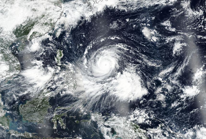
While the United States East Coast prepares for Hurricane Florence to make landfall, parts of Southeast Asia are staring down an even bigger storm: Super Typhoon Mangkhut (known as Super Typhoon Ompong in the Philippines).
The super typhoon would be considered a strong Category 5 storm in the Atlantic Ocean, with estimated winds of 253 kilometers per hour (157 miles per hour). The storm threatens the heavily populated coasts of Hong Kong and Macau, and has already caused flooding in Guam. It is likely to strengthen in the coming hours and strike the Philippines farther along its path.
Experts warn heavy rain and flooding are likely in the region, with the possibility of significant damage.
So why is Mangkhut called a super typhoon while Florence is a hurricane? As in real estate, it’s all about location, location, location.
That’s because hurricanes, typhoons, and cyclones are all different names for the same type of storm.
The storms that rage across the western Pacific Ocean (in the Eastern Hemisphere) are called typhoons, while the ones spawned in the Atlantic and eastern Pacific (the Western Hemisphere) are called hurricanes. Those born in the South Pacific and Indian Ocean are known as cyclones.
Hurricanes are named after Hurrican, a Caribbean god of evil. "Typhoon’s" origins are complicated, with possible roots in Persian, Arabic, and Chinese words that referred to strong storms. The word also passed through numerous other languages, from Portuguese to Greek.
Collectively, hurricanes, typhoons, and cyclones are known to scientists as "tropical cyclones," and can span an area up to 1,609 kilometers (1,000 miles) in diameter.
To classify as a tropical cyclone a storm must reach wind speeds of at least 119 kilometers (74 miles) per hour. If a storm's winds reach speeds of 178.6 kilometers (111 miles) per hour, it is upgraded to an intense hurricane or typhoon.
And although Atlantic hurricanes get the lion's share of media coverage in North America, those storms actually only account for about 11 percent of all tropical cyclones, Kerry Emanuel, an atmospheric scientist at the U.S. university, the Massachusetts Institute of Technology (MIT), previously told National Geographic.
It's that Time of Year
Globally, the tropical cyclones develop most often in late summer, when there is the greatest difference in temperature between the air and water. Worldwide, May is the least active month and September is the most active. In the Atlantic, a distinct hurricane season persists from about June 1 to November 30, after which air and water get too cool for the storms to develop.
Parts of the western Pacific are warm enough for the storms to develop at any time during the year, although the summer and early fall are still the most common periods.
No matter what the storms are called, they all need the same things: storm clouds, surface ocean temperatures above 27°C (80°F), and very little difference in wind speeds from the surface to high in the sky. Beyond that, scientists are still trying to understand what triggers them, MIT's Emanuel said.
How Storms Work
Once a storm gets going, it is fueled by the evaporation of water into the air. Warm ocean waters feed that evaporation, cooling the immediate area and sucking more heat to the center of the storm. This sets up a cycle that keeps running until one or more of several factors stop it.
Those factors can include high wind shear, which can break up the storm or slow it down by blasting it with dry air. When the storms make landfall, they lose their ability to evaporate large amounts of water (because they are no longer over it). The churning winds also can drag up cold water from the ocean deep, which results in less evaporation potential and robs the storm of power.
The storms are categorized by the strength of their winds, although the wind itself often isn't the deadliest part of the tempest. Storm surges—pulses of water pushed by the advancing cyclone—often result in coastal flooding, which can cause drowning and the collapse of structures.
Surges were responsible for much of the devastation caused by Super Typhoon Haiyan in the Philippines in November 2013 (the storm was called Yolanda there). Haiyan was one of the largest and strongest storms ever recorded, with winds that reached 315 kilometers (196 miles) per hour. Storm surges as high as 7.6 meters (25 feet) washed away buildings, ripped up vegetation, and killed over 6,000 people.
Such powerful storms may become more likely thanks to the warming of the air and water through climate change, Emanuel warns.
This article was originally published August 8, 2019.
